DCHP-2
49th parallel forty-ninth parallel DCHP-2 (July 2016)
1 n. — Geography
the section of the circle of latitude 49 degrees north of the equator that marks the international border between Canada and the US (see Image 1).
Type: 4. Culturally Significant — In 1818, following the War of 1812, British and American governments agreed to make the 49th parallel the official western border between Canada and the US, from the Lake of the Woods (which borders Ontario, Manitoba and Minnesota) up to the Rocky Mountains. The area west of the Rocky Mountains was known as the Columbia District (by Canadians) or Oregon Country (by Americans) and its ownership was disputed until the Oregon Treaty of 1846 was established (also known as the Treaty of Washington in the US), which extended the international border along the 49th parallel to the Strait of Georgia. See also the Canadian Encyclopedia reference.
See also COD-2, s.v. "forty-ninth parallel", ITP Nelson, s.v. "forty-ninth parallel", and DA, s.v. "forty-niner" (10a).See also: down south south of 60 north of 60
2 n. — in figurative use
the Canada-US border in general.
Type: 4. Culturally Significant — the expressions 'north of the 49th parallel' and 'south of the 49th parallel' have become synonymous with 'in Canada' and 'in the United States' (see also down south, meaning 2, for the latter). This figurative meaning is the most prevalent one today.See also: down south (meaning 2)
References:
- COD-2
- Canadian Encyclopedia s.v. "Oregon Treaty" Accessed 17 Feb. 2016
- DA
- ITP Nelson
Images:
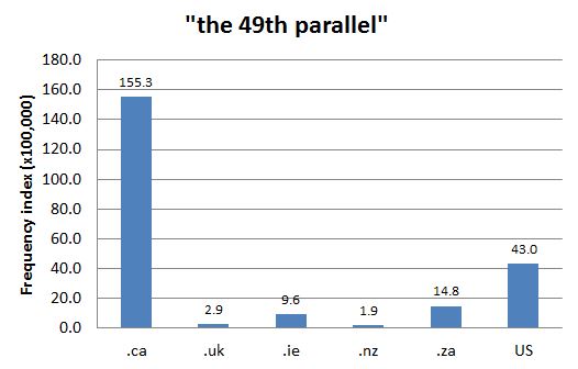
Chart 1: Internet Domain Search, 9 May 2014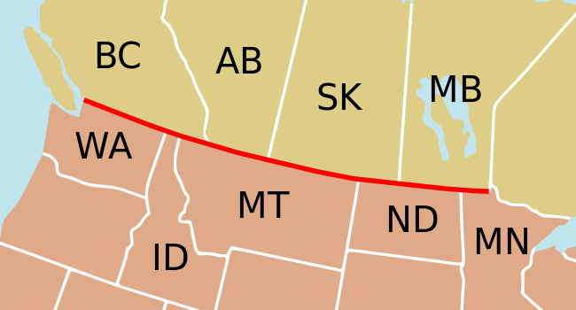
Image 1: The Canada-US border along the 49th parallel. Source: Wikimedia Commons. Image: Bazonka